 Skip to content
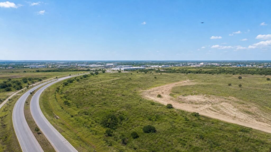
Short answer: drone video for land development is most valuable when it helps a viewer understand the visible context of a site: how it relates to roads and surrounding uses, how the site appears at a given point in time, and what a proposed story or update needs to show. It is a marketing and communication asset, not a survey, legal-access opinion, boundary determination, title review, entitlement report, inspection, engineering finding, or certified progress record.
That boundary makes the work more useful, not less. A development team may need a landowner, investor, broker, tenant prospect, community stakeholder, or internal leadership group to orient quickly to a site. Carefully planned aerial footage can do that better than a collection of isolated ground photos. But it must be paired with accurate project-approved language and the documents that actually govern acreage, access, boundaries, schedule, and development status.
This is a narrower topic than Nitro's drone-video guide for San Antonio businesses, which covers the broad decision of whether aerial media is worth considering. Here, the goal is to plan a land-development video that supports a credible story without asking a camera to prove something it cannot.
What can drone video actually communicate about a development site?
Drone video can communicate visual orientation, apparent scale, the relationship between visible roads and the site, approved surrounding context, and visible change from one approved capture date to another. It is especially useful when a viewer needs to understand the site before they see a map, a rendering, an offering package, or a project update.
The strongest aerial sequence has a defined audience question behind it. For example, a leasing or marketing team may need to show how a site sits in relation to a visible corridor. A development team may need a broad visual update for stakeholders. A broker may need a short approved clip that introduces a land opportunity before a viewer opens the full materials.
The camera should not be asked to settle questions that depend on formal project records. Footage can show an apparent driveway or visible roadway connection; it cannot establish legal ingress, egress, easements, road rights, or future access. It can give a viewer a sense of scale; it cannot verify acreage, property lines, setbacks, utility capacity, grade, drainage, zoning, permitted use, title, environmental conditions, or entitlement status. It can show visible activity; it cannot certify project progress, workmanship, safety, schedule performance, or completion.
| If the audience needs to understand | Aerial media can help show | The source of truth still belongs to |
|---|---|---|
| Site context | Visible roads, neighboring land uses, buildings, open areas, and the site's apparent relationship to them | Approved plans, maps, and project records |
| Access story | A visible approach or adjacent corridor, when approved for filming | Title, legal, civil, and project professionals |
| Site scale | A broad visual impression and the relationship of visible features | Survey, plats, legal descriptions, and approved materials |
| Development status | Visible change on a specific capture date | The project team and its approved schedule/status reporting |
| Marketing narrative | The location, setting, and approved story arc | Marketing, ownership, and project approvers |
For broader context on why businesses use aerial media, Nitro's commercial-drone applications guide is a useful companion. The land-development version should stay disciplined: context before spectacle, qualified records before claims.
How should a land-development team think about access, acreage, and progress?
Treat access, acreage, and progress as three different communication problems. Each can benefit from aerial storytelling, but each needs a different approval path and a different source of truth.
Showing access without making an access claim
Aerial media can introduce how a visitor visually approaches a site, where visible roadways sit in relation to the property, or how a completed development may connect to a broader area. That can help a viewer understand orientation in a short video, social cut, pitch deck, or landing page.
The copy and edit must stop short of legal or logistical claims. Avoid labels such as “guaranteed access,” “direct highway access,” “future exit,” “easy truck access,” or “minutes from” unless the owner has supplied approved, current, and supportable language. A better production request is: “Show the approved exterior context and visible approach from a safe, allowed vantage point.” A better caption is: “Aerial view showing the site in its visible surrounding context, captured on [date].”
The location-scouting process is a practical companion for deciding which publicly visible or client-approved views serve the story. The location and project team—not the production crew—should decide what is approved to show and what requires a separate map, graphic, or project disclaimer.
Showing acreage as scale, not a measurement
Land footage is good at conveying scale. A high, wide shot can help someone compare open ground, buildings, roads, drainage features, vegetation, and adjacent development in one frame. That visual context can make a land page or investor update easier to understand.
It does not convert a visual impression into a measurement. Do not overlay a parcel outline, acreage number, boundary line, setback, utility route, or future building footprint unless the land-development team has provided an approved graphic and the final use is cleared by the appropriate owner. Never draw a guessed boundary on a hero image just because it would make the page look more technical.
When a property-marketing package needs a formal plan, use the correct approved materials alongside the video. Nitro's real estate video walkthroughs versus 3D tours guide can help a marketing team separate the role of a visual story from the role of an interactive or informational experience. The same principle applies to land: give the aerial video one job, then let maps and project documents carry theirs.
Showing progress as visible change, not certification
For a development moving from raw land through site work, infrastructure, vertical construction, landscaping, or opening, matched aerial views can create a useful visual timeline. The key word is matched. Repeating a small number of approved, clearly labeled viewpoints makes it possible for a stakeholder to see visible change without pretending that the video is a technical progress report.
Use date labels, approved phase names, and a short project-team note. Do not have the video production team write claims about completion percentages, construction quality, delivery dates, inspection status, or schedule health. If a project team wants to distribute a milestone update, its designated owner should provide the final language and decide which images are fit for internal use, public marketing, lender communication, or a future case study.
Which land-development stories benefit most from aerial footage?
Aerial video is not mandatory for every land project. It earns its place when the viewer needs a quick, reliable orientation that ground media cannot provide. The best fit is usually a project with a clear story and an approval path—not simply a lot of acreage.
| Story type | Good aerial contribution | What the team should approve first |
|---|---|---|
| Land or development overview | Establish the visible site context and approved surrounding area | Audience, approved claims, no-film areas, and the proper companion materials |
| Investor or stakeholder update | Show dated, repeatable views of visible change | The exact update language and whether the media is internal or public |
| Broker or leasing presentation | Give a short orientation before a viewer opens maps and offering documents | Every location, access, acreage, and availability statement |
| New-community or campus story | Connect approved exterior views, visible roads, and finished amenities | Brand, privacy, construction, and public-release approvals |
| Recruiting or company narrative | Show an approved development setting as part of a broader business story | Site access, people/privacy, and the message the business can substantiate |
The corporate-video production guide for San Antonio is useful if this footage will become part of a larger brand film, investor presentation, recruitment piece, or launch campaign. A land-development aerial sequence should act as an orientation chapter in that story, not become an unsupported claim engine.
What should be in the brief before a drone shoot is scheduled?
Write a one-page brief before the date is proposed. It gives the development, marketing, land, and production teams a shared version of the assignment. It also makes it much easier to replace a shot that is not appropriate on the day rather than pressuring a crew to make it happen.
Include these items:
- Audience and use. Identify whether the deliverable is for a project update, broker package, investor deck, public website, social campaign, recruiting film, or an internal archive. One primary use makes approval simpler.
- Single story statement. Write one sentence that says what the viewer should understand after watching. For example: “This approved overview helps a viewer orient to the site and visible surrounding context.” Avoid claim-heavy sentences.
- Approved and excluded areas. List locations that may be filmed and a no-film list for adjacent private property, security-sensitive infrastructure, confidential plans, people, vehicle plates, temporary signage, or client material.
- Required source materials. Identify the project-approved map, rendering, branding, terminology, and any footnotes that should be supplied by the owner or marketing lead. The production team should not invent these.
- Shot purposes. Give each proposed shot a job: establish context, show a visible approach, reveal a completed amenity, create a date-labeled progress comparison, or transition to a ground-level interview.
- Site and aviation contacts. Assign the person who handles property access, the day-of site contact, the project/marketing approver, and the remote-pilot point of contact.
- Deliverables and review. Decide whether the scope includes selected stills, short unedited clips, a landscape edit, vertical cuts, raw-footage access, dated archives, and who signs off before each use.
- Fallback plan. Name a safe alternative if access, weather, airspace, activity, privacy, or site conditions make a planned sequence unsuitable. An omitted aerial shot is better than a rushed one.
The purpose of the brief is not to prescribe a flight. It is to describe the communication goal and provide enough information for the responsible people to plan appropriately.
What FAA considerations should a development team raise early?
For commercial aerial filming, the responsible remote pilot needs to evaluate the current FAA framework and the exact proposed operation. The FAA's commercial-operator guidance describes the Part 107 path for small UAS used for work or business, including the remote-pilot and registration context. A blog post, property owner, or marketing deadline cannot determine in advance that a particular operation will be allowed.
The exact location matters. A property owner's permission to access a site is not the same thing as airspace authorization. The FAA's LAANC guidance explains that drone pilots operating in controlled airspace around airports must receive authorization before flying and that pilots must still check NOTAMs, weather, and applicable airspace restrictions. The remote pilot should make that assessment for the planned date and location, not rely on a screenshot or an old address lookup.
Remote ID is another current-operation check. The FAA explains in its Remote ID guidance that drones required to be registered, or that are registered, must operate in accordance with the Remote ID rule. The article does not need to tell a buyer how to configure a particular aircraft; it should prompt the buyer to ask the remote pilot how current requirements will be handled.
For reader-friendly background, Nitro also has a drone-pilot license guide. For a real flight decision, however, current FAA and applicable operational guidance take precedence over any general blog explanation.
What does a useful land-development shot list look like?
A good land-development shot list is a small collection of story-driven views, not a request to fly everywhere. Each item needs a purpose, an approval owner, and a ground or graphic fallback.
| Shot purpose | Visual objective | Non-aerial fallback |
|---|---|---|
| Orientation opener | Establish visible site and approved surrounding context | Approved map graphic, ground exterior, or a licensed overview image |
| Visible approach | Help a viewer see an approved route or corridor in context | Ground arrival sequence or approved static exterior |
| Scale and relationship | Show the apparent relationship of open land, roads, existing buildings, and approved features | Approved site plan or a sequence of ground-wide shots |
| Progress comparison | Match a dated prior approved vantage point to show visible change | Labeled ground photos or a project-approved update graphic |
| Story transition | Move from the aerial context to a spokesperson, rendering, sign, or project detail | Gimbal movement or a graphic transition |
| Finished-environment view | Show an approved, completed exterior context | Ground-level exterior or licensed/approved photography |
Notice what is missing: guessed boundary overlays, fake flight-path graphics, “future development” labels without approved artwork, and shots selected solely because they look dramatic near people, vehicles, construction activity, utilities, or private property. A disciplined edit can feel cinematic without turning the site into a visual stunt.
The why the right video-drone operator matters more than the drone guide is useful at the hiring stage. For land work, the critical question is whether the team can coordinate an approved story, site access, a legally aware airspace review, and a sensible alternate shot—not whether it can list the most drone features.
Should the production team use stills, video, or both?
Most land-development packages benefit from both, but each asset should have a defined role. Stills are useful in decks, landing pages, status emails, brochures, and side-by-side progress comparisons. Video is useful for orientation, emotional pacing, and explaining how multiple approved visual elements relate.
| Deliverable | Best job | Approval question |
|---|---|---|
| Selected aerial stills | Decks, web pages, proposal support, and dated archive | Does each image show only approved property/context and need an accompanying disclaimer? |
| Short landscape clip | Website header, presentation opener, or stakeholder update | What exact message will appear next to it? |
| Vertical social cut | Controlled launch, recruiting, or awareness use | Is the crop still clear without creating a misleading claim? |
| Edit with maps or renderings | Context story that needs approved informational materials | Who owns the final map, rendering, label, and disclaimer accuracy? |
| Raw or source footage | Internal archive and future edit source | Who may access it, retain it, or approve material for public use? |
Keep the production and property-media roles clear. Nitro's real estate drone photography guide can help readers think through the visual appeal of property aerials. This article adds the extra land-development discipline: attractive visuals must remain tied to approved claims and source documents.
How should the team review a land-development aerial edit?
Review the edit in two passes. The first pass is creative: does it orient the right audience, tell one understandable story, and make good use of aerial context? The second is factual and approval-focused: does every visible label, caption, map, rendering, date, and claim come from the right project owner?
Use this review sequence:
- Story review. Does the first 10 seconds make clear what the viewer is looking at and why it matters?
- Visual approval review. Are all sites, roads, neighboring properties, signs, people, vehicles, screens, and work areas cleared for the intended use?
- Claim review. Remove or approve every statement about acreage, access, availability, zoning, schedule, market timing, completion, or future development.
- Source-material review. Confirm that maps, parcel graphics, renderings, and project facts came from approved current materials and are not improvised in the edit.
- Distribution review. Decide whether the version is internal, investor-facing, broker-facing, public, paid social, or a portfolio asset. Each distribution route may need a different approval.
- Archive review. Label what was captured, on what date, under what project scope, and who may reuse it. A clean archive prevents future teams from mistaking raw footage for an approved public asset.
If a business is selecting a broader production partner, Nitro's San Antonio video-production company guide can help frame the selection around planning, communication, and delivery—not simply a camera list.
Can drone video replace a survey, site visit, map, or project update?
No. It is a complementary visual asset. Aerial media may make a viewer ask a better question or understand a project story more quickly, but it does not replace the people and documents responsible for measurements, boundaries, access rights, engineering, planning, legal conclusions, construction administration, safety, or official project status.
The strongest use is a paired format: an approved aerial sequence for orientation, approved supporting materials for facts, and a project-team voice for any formal update. That format gives the viewer a more complete picture while protecting the integrity of the actual project records.
Bottom line: make the visual story clear and the factual boundaries clearer
Drone video for land development is valuable when it explains visible context with restraint. Plan it around a viewer's need to understand a site's setting, apparent scale, and visible moment in time. Then keep the claims, maps, labels, dates, and supporting information in the hands of the people who own and can verify them.
Start with one approved story, a short no-film list, a clear source-material owner, a responsible remote pilot, and a fallback for the shot that cannot safely or appropriately happen. The result is more credible than a generic flyover: a useful visual companion to a land-development narrative, not a substitute for the formal materials behind it.


